Betters Homestead / Pine Grove House in Pineland Grove
As I noted in a post from 2015, Don Bert Omundson's 1961 thesis "Study of place names in Missoula County, Montana" was a real breakthrough for my Clinton/Betters research. His thesis included some supplementary pages, labeled "Miscellaneous information from Missoula Courthouse records about some of the places and men mentioned in the following thesis." In those pages was information about property acquired by Austin Betters in 1883.
In 2017, I traveled to the Missoula County Record Center and found the deed referenced by Omundson. That deed has since been digitized and is now available online at the Missoula County Clerk & Treasurer's website (See below).
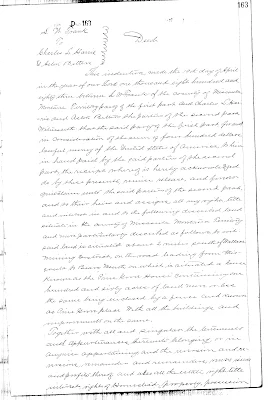

The quitclaim deed is dated April 19, 1883, and transfers the property from L.W. Frank to Charles L. Harris and Astin [sic] Betters for $400. Here is the description of the property:
said land is situated about 2 miles south of Wallace Mining District, on the road leading from Missoula to Bears Mouth on which is situated a house known as the "Pine Grove House" containing one hundred and sixty acres of land more or less the same being enclosed by a fence and known as Pine Grove Place with all the buildings and improvements on the same.
If the house was known as the Pine Grove House, it apparently wasn't known by that name by many people. I have done numerous searches for "Pine Grove House" and "Pine Grove Place" in newspapers, government records, and Montana history books over the years and I always come up empty. I did discover a community near Bonner (13 miles downriver from Clinton) called Pinegrove, but it has no connection to the "Pine Grove House" or "Pine Grove Place."
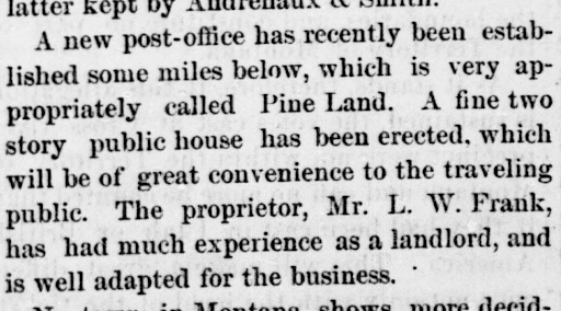
What I have found (and what Omundson apparently found before me), is that L.W. Frank was the postmaster of a post office called Pineland from October 30, 1882 to April 2, 1883, and Edward Frank (presumably a relation) preceded him as postmaster from July 28 to October 30, 1882.
It's important to provide some historical context here. In the American West in the late 19th century, being a postmaster wasn't simply a job. If you were appointed postmaster, your residence and/or place of business was the post office. That's why it was so wonderful to find the following in the "JOTTINGS OF A WANDERER" column in the November 23, 1882 issue of the Helena Weekly Herald:
What about location? We know from the deed that the property "is situated about 2 miles south of Wallace Mining District, on the road leading from Missoula to Bears Mouth." The only road through the Hellgate Canyon in 1883 was the Mullan Road, and the canyon was (and is) narrow enough that you can pretty well guess where the 160 acres were, but I was confused as to why I could never find the Betters name on any of the old maps, especially if Austin was an early homesteader in the area who supposedly had the town named after him for a time.
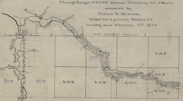
I finally realized at some point that a plat map I had looked at many times before showed me exactly where the Betters' home was. It's just that the black square marking the location of the Pine Grove House was labeled with Charles' last name, not Austin's. See below. This is the plat map for T11N R17W. This area was surveyed on November 14, 1883, and the map was signed by the Surveyor General on January 14, 1885. The five sections you see here are the only parts of the map that have any detail. The other 31 sections are completely blank. The Harris-Betters home is the only building shown on the map. The other manmade features on the map are the Northern Pacific Railroad, the "U.S. Military Road" (the Mullan Road), and what I believe to be an irrigation ditch by the "Harris" home. If you zoom in you can see "sluice" written very faintly in pencil.

Does any of the information above lend credence to the prevailing origin story of Clinton, that it was started as a stage stop on the Mullan Road in 1883, and the place was originally named "Betters' Station" after my great-great-grandpa Austin Betters? Personally, I think quite the opposite. Here are some of my thoughts, in no particular order:
- While the Pine Grove House is not referred to as a stage station in any of the documentation above, it's plausible that it was one. Stage stations and post offices were often one and the same, and while the smaller stations only supplied fresh horses and an opportunity for travelers to stretch their legs, the larger stations provided meals and lodging. The newspaper does call the Pineland post office a "public house" and states that it "will be of great convenience to the traveling public," so it was probably more than a post office.
- Even if the property was run as a stage station after Charles and Austin acquired it, it can't be said that Clinton started as a stage stop on the Mullan Road in 1883. The partners bought the property from L.W. Frank, who established it the year before.
- If it was a stage station, the location of the property doesn't make sense to me. Yes, it was on the highly trafficked Mullan Road, but there were already many other well-established stage stations in the Hellgate Canyon, and the nearest one was just a couple miles away, near the Wallace Mining District.
- The timing doesn't make sense to me, either. In April 1883, construction on the transatlantic Northern Pacific Railroad (which followed the route of the Mullan Road through the Hellgate Canyon) was nearly complete. Surely anyone could see that the railroads were quickly becoming the preferred mode of transportation for mail, freight, and human travelers. Why would anyone establish a stage station there a few months before the final spike was driven, rendering the stagecoaches obsolete?
- Based on when the plat map was created (1883-1885), if people were calling the Betters-Harris property "Betters' Station," you would think that the Surveyor General's Office would have labeled the house as such. At the very least, the Betters name should have been used in place of, or in addition to, the Harris name.
One other thing: Who was Charles L. Harris?
While the deed, the newspaper column, and the plat map I shared above connected a lot of dots for me, they also generated a number of questions that I have not yet been able to answer. Among them:
- Who is Charles L. Harris, how did Austin know him, and why did he and Austin decide to partner on the purchase of this property?
- What happened with the partnership?
- Why can't I find any evidence of Austin buying out Charles' interest before Austin deeeded the property to someone else in 1900?
Sidenote: An unlucky break for L.W. Frank?
I don't know anything more about Edward and L.W. Frank beyond what I have shared above. I don't know what they were doing before they established the Pineland post office in 1882 and I don't know what happened to them after L.W. Frank sold the Pine Grove House to Austin and Charles in April 1883.
However, the Benton Weekly Record did report on June 2, 1883 that L.W. Frank of Missoula had arrived in Fort Benton and was registered at the Grand Union. A week later, they reported that "L.W. Frank, an old man who had recently arrived from Butte, was robbed of $422.50." I don't know if this is the same L.W. Frank who sold his property to Austin and Charles for $400 less than two months earlier, but if it is, what awful luck, to have all the proceeds from that sale stolen.


Comments
Post a Comment